
North India is experiencing an intense heatwave, with temperatures soaring to 48 degrees Celsius in some areas. Several states have issued warnings and advisories as the heatwave is expected to continue.

Many places across northern states including Delhi recorded above-normal temperatures crossing 40 degrees Celsius, while the India Meteorological Department warned of heatwave conditions in parts of Uttar Pradesh in the coming days. Jammu and Kashmir saw a dip in temperatures with fresh snowfall in the higher reaches and rainfall in the plains.

Northern states in India are experiencing severe heatwave conditions, with temperatures reaching up to 46.6 degrees Celsius. The heatwave has impacted daily life, leading to a decline in tourism and increased power demand. Authorities have issued advisories and implemented measures to mitigate the effects of the extreme heat.

'This system will be of immense help in agricultural planning, disaster management and water resources management.'

Researchers at IIT Bombay have discovered that heatwaves in the Indo-Gangetic Plains are primarily caused by local land and weather conditions, rather than hot air originating from elsewhere, emphasising the need for location-specific early warning systems.

A severe cold wave has gripped North India, with temperatures plummeting to near-freezing levels in several areas. The cold wave has disrupted daily life, with dense fog affecting visibility and forcing people to stay indoors.

Large parts of India are experiencing a severe heatwave, with temperatures soaring to dangerous levels. Authorities have issued alerts and health advisories as the heatwave intensifies across multiple states.

The India Meteorological Department (IMD) reports that ash clouds from volcanic activity in Ethiopia, which impacted flight operations in India, are drifting towards China and will move away from India by 7.30 pm on Tuesday.

Several states in north India, including Rajasthan and Himachal Pradesh, experienced varied weather conditions, including light to moderate rainfall, fog, and temperature fluctuations.

Delhi recorded its coldest January morning in three years with the minimum temperature dropping to 3 degrees Celsius. Cold wave conditions are expected to persist, and air quality has deteriorated to the 'very poor' category.

The national capital was in the grip of a cold wave, with the sun largely obscured by clouds and pollutants lingering in the atmosphere, leading to reduced visibility. At least 129 flights were cancelled at the Delhi airport on Saturday due to dense fog, according to an official.

Delayed by 10 days due to cyclone Biparjoy, southwest monsoon is likely to progress further and hit Mumbai between June 23 and 25, the India meteorological department said on Wednesday.

Heavy rains lashed Delhi, leading to a red alert, traffic snarls, and waterlogging. The IMD predicts continued rainfall.

Palghar, Thane, Raigad and Ratnagiri could witness thunderstorm activity, lightning, moderate rain and gusty storm over the next two days.

"Montha over westcentral Bay of Bengal moved north-northwestwards with a speed of 17 kmph during the past six hours and lay centred at 2.30 am on October 28 over the same region about 230 km south-southeast of Machilipatnam (and) 310 km south-southeast of Kakinada," said the Met Department in a release.
Cyclone Ditwah is moving towards the Tamil Nadu coast, bringing the threat of heavy rainfall. The state government is reviewing preparedness measures, and a red alert has been issued for southern and delta districts.

The state broadcasters have started the practice, but private news channels may follow suit, a ministry source said.

The India Meteorological Department's (IMD) regional centre for Mumbai has issued a 'yellow alert' for next three days, predicting heavy to very heavy rainfall at isolated places.

Mumbai, its satellite cities, north and central Maharashtra and south Gujarat received rains on Wednesday owing to a low-pressure area in the Arabian Sea and a western disturbance, the India meteorological department said.

The aircraft, later, flew to Guwahati after an improvement in the weather conditions in Guwahati, said KC Meena, the director of the Maharaja Bir Bikram (MBB) Airport at Agartala.

Heavy rains had battered the metropolis on Sunday and Monday as well.

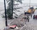
A landslide triggered by continuous rainfall has disrupted traffic on National Highway 75 near Kadaba taluk in Dakshina Kannada district, halting vehicular movement between Bengaluru and Mangaluru. Authorities are working to clear the debris and restore traffic flow.
Experts question whether a cloudburst caused the recent flash flood in Uttarkashi, India, citing insufficient rainfall and other potential factors like ice chunks, rockfalls, or landslides.

As Myanmar grapples with crises in the aftermath of deadly cyclone Nargis, another tropical storm appears headed for its shores, the India Meteorological Department said on Wednesday. The IMD, which is the Regional Specialised Meteorological Centre of the World Meteorological Office, has issued a advisory on the impending extreme weather condition. The United Nations has warned that the Myanmar could face a 'second catastrophe'.

The India Meteorological Department has issued a 'Red Alert' and predicted 'very heavy' to 'extremely heavy' rainfall across several districts of Assam over the next five days.

According to the IMD, a rain event is categorised as a cloudburst if a weather station receives 100 mm of rain in one hour.

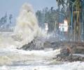
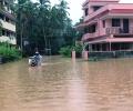
Heavy rains across India have led to widespread flooding, causing damage to infrastructure, displacement of residents, and disruption of normal life. Rescue efforts are underway in affected areas.
A new study identifies flash flood hotspots in India, highlighting the influence of land features, rainfall, and the growing impact of climate change.

Severe cyclonic storm 'Montha' has begun making landfall off the Andhra Pradesh coast, with the process expected to continue for the next three to four hours. The storm is expected to cross the coast between Machilipatnam and Kalingapatnam, near Kakinada, with wind speeds of 90-100 kmph.

The India Meteorological Department has issued a 'Red Alert' and predicted 'very heavy' to 'extremely heavy' rainfall across several districts of Assam till Thursday.

Cyclonic storm Fengal has commenced making landfall close to Puducherry and it may approximately take 4 hours for it to cross the coast completely, an India Meteorological Department (IMD) official said. The process of the cyclone's landfall commenced at about 5.30 pm on November 30. The IMD said the forward sector of spiral bands associated with the cyclone has entered into the land and is likely to move west-southwestwards and cross north Tamil Nadu-Puducherry coasts between Karaikal and Mahabalipuram close to Puducherry as a cyclonic storm with a wind speed of 70-80 kmph gusting to 90 kmph during next 3 to 4 hours.

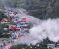
At least 23 people, including children, were killed as relentless rain triggered one of the worst landslides in a decade in Darjeeling hills and adjoining areas on Sunday, sweeping away homes, cutting off roads, isolating villages, and leaving hundreds of stranded tourists amid widespread devastation, officials said.

Lightning claims more lives in India annually than any other extreme weather event. Between April and July this year alone, 1,621 people died due to lightning strikes.

Intermittent, widespread rains lashed Chennai and other regions of Tamil Nadu on Tuesday and the India meteorological department said the low pressure area over the Bay of Bengal has turned into a well-marked low pressure area and it is likely to become a depression.
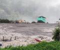
A cloudburst in the high altitude villages of Dharali in Uttarkashi district of Uttarakhand led to flash floods, causing damage to houses and sweeping away structures. Several people are feared buried under debris.
Heavy monsoon rains battered Karnataka's coastal belt for the third consecutive day on Monday, severely disrupting normal life in Dakshina Kannada district, prompting authorities to issue a red alert and deploy disaster response teams. A red alert indicates extremely heavy rainfall of over 20 cm in 24 hours, and will remain in force for the next five days, according to the India Meteorological Department (IMD). Several parts of Mangaluru city reported waterlogging and traffic snarls, while minor incidents of landslides were reported from hilly regions across the district. The district administration has directed schools and composite colleges to remain shut on 27 and 28 following the IMD issuing a red alert. Instructions were also issued to relocate residents living in vulnerable hillside and riverside areas to safer locations. The authorities have sought prompt action from the National Highways Authority of India (NHAI) following complaints of water intrusion in residential areas due to ongoing highway construction works.

The Met office had said Monday that significantly higher-than-normal temperatures may have an adverse impact on wheat and other crops.

'It is very likely to move nearly northwards for next few hour and recurve slowly north-northeastwards along Narsapur, Yanam, Kakinada, Tuni and Visakhapatnam coasts during noon to evening on Wednesday and emerge into west central Bay of Bengal off North Andhra Pradesh coasts by night,' the India Meteorological Department said in its national bulletin.

All 80 people stuck at Pali waterfall in Goa's Sattari taluka were rescued on Sunday by the state's Fire and Emergency Services and the police, an official said.

IMD data shows in the 24 hours between September 1 and 2, Haryana received 806 per cent more rainfall than normal, Punjab 759 per cent, Himachal Pradesh 510 per cent, Delhi 740 per cent, Chandigarh a staggering 1,638 per cent, and Rajasthan 193 per cent.